Millions of travelers heading home after the Christmas holiday are bracing for significant disruptions as stormy weather sweeps across the United States. Rain, severe thunderstorms, and snow are expected to create challenging travel conditions nationwide as the week concludes.
Severe Weather Outbreak Threatens the South
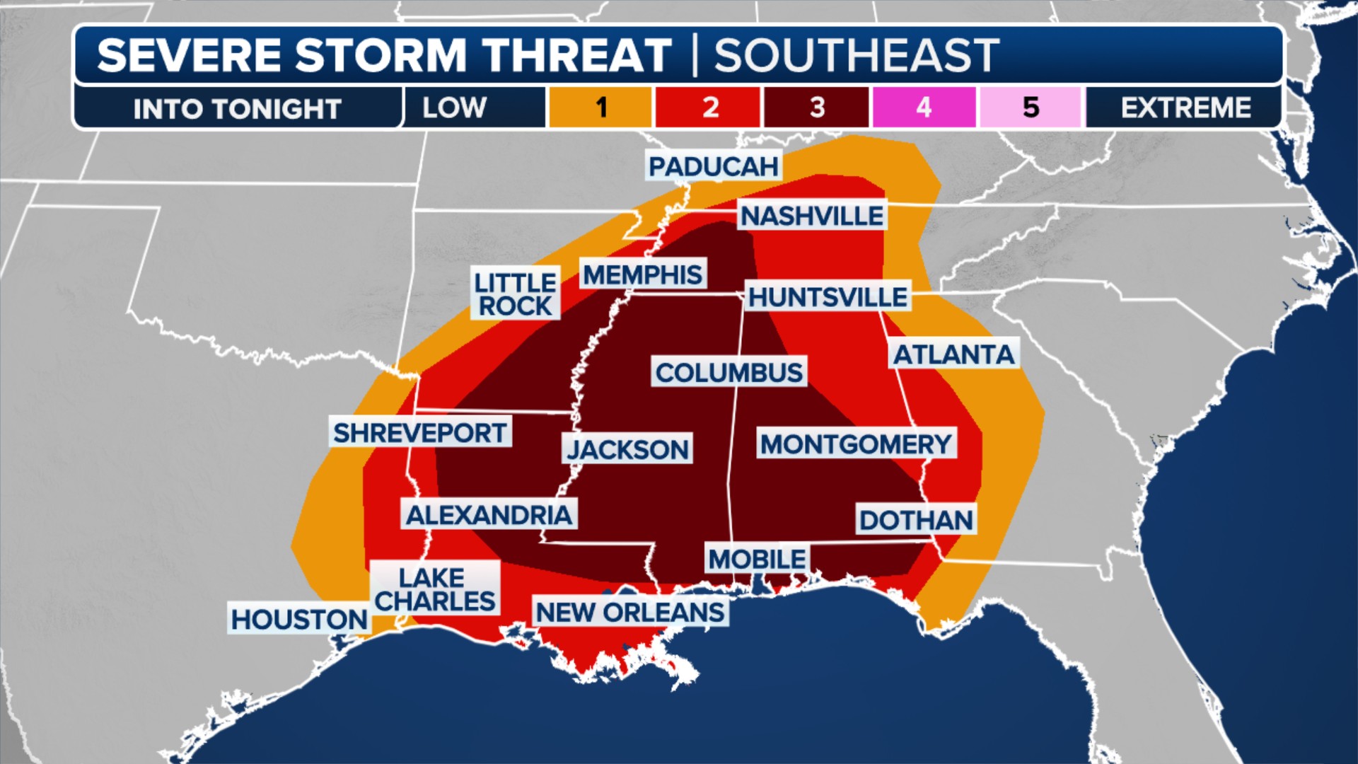
The southern United States is facing a heightened risk of severe weather, marking the third consecutive day of such conditions and potentially the most intense. Following reports of tornadoes in Texas on Thursday and Alabama and Mississippi on Friday, the threat escalates further on Saturday.
Large portions of Louisiana, Mississippi, Arkansas, and Alabama are under a severe weather threat zone, as indicated by NOAA’s Storm Prediction Center. Residents in these areas should be particularly vigilant and stay updated on the evolving forecast.
 The severe weather outlook for Dec. 28, 2024.
Multiple rounds of severe weather are anticipated throughout Saturday and into Saturday night. The SPC cautions that strong tornadoes, large hail, and damaging winds are all possible. Individuals in the affected regions are urged to monitor weather alerts closely and have safety plans in place.
Northeast Braces for Rain and Potential Ice
The Northeast region, which recently experienced a rare white Christmas in New York City for the first time in 15 years, is now preparing for a rapid shift to milder temperatures and persistent rainfall. The FOX Forecast Center is tracking several weather systems expected to bring wet and unsettled conditions to the Northeast as millions journey home after the holidays.
The weather system responsible for Thursday’s severe weather in the Southern Plains is now weakening as it moves through the Northeast on Friday. While weakening, this system still poses a threat of light freezing rain across parts of northern New Jersey, northeastern Pennsylvania, south-central New York, Connecticut, and western Massachusetts. Winter Weather Advisories are in effect until Saturday morning, warning of potential ice accumulation of up to 0.10 inches in some locations.
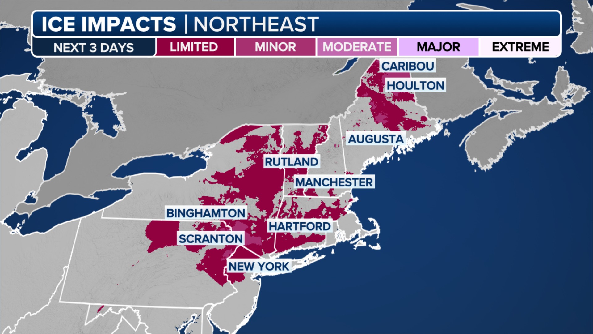 Freezing Rain forecast Friday night.
A second system is expected to arrive on Sunday, originating from the Rockies and drawing Gulf moisture northward into New England. This could lead to a risk of flash flooding in the interior Northeast. Looking ahead to New Year’s Eve, a third weather system could bring rain, potentially impacting celebrations and outdoor plans.
West Coast Hit by Relentless Storms
The Pacific Northwest continues to experience its characteristically rainy weather as a series of storms from the Pacific Ocean persist through Saturday. By the weekend, the region will have been impacted by seven separate weather systems, including atmospheric rivers of varying intensity. Seattle has already recorded 16 consecutive days of rainfall as of Friday.
Western Washington, Oregon, and northern California are expected to receive several more inches of rain. The cumulative effect of these repeated rainfall events is increasing the risk of flooding and landslides at lower elevations throughout the week. In the higher elevations of the Cascades, over 7 feet of snow is possible. Mountain passes are experiencing hazardous driving conditions, with heavy snow frequently causing spinouts and road closures.
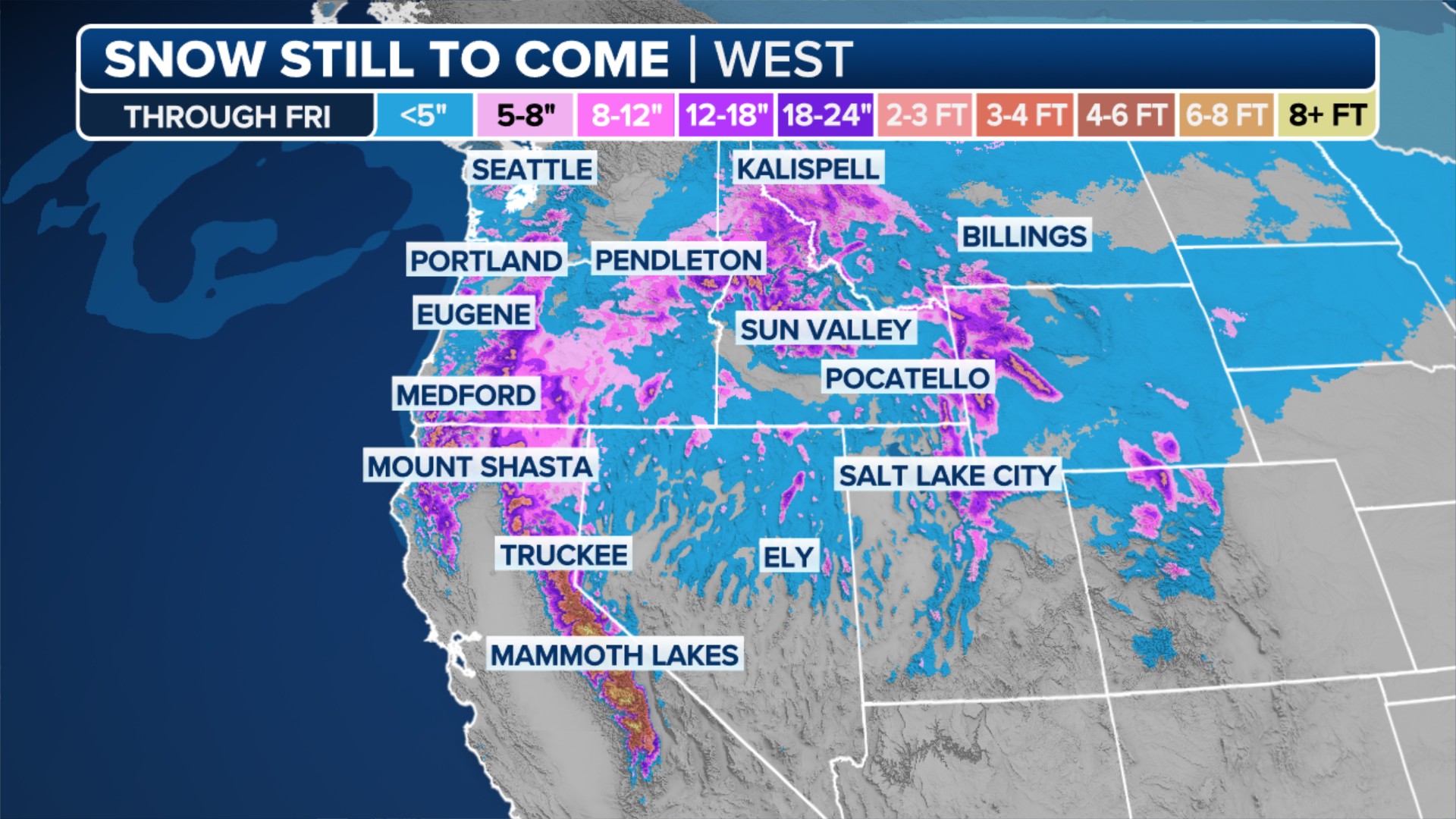 A look at the snow still to come along the West Coast through Saturday.
Travelers across the United States are advised to stay informed about the latest weather forecasts and travel advisories as stormy conditions are expected to cause significant disruptions in multiple regions.