Storm surges can travel surprisingly far inland, posing a significant threat to coastal and inland communities; TRAVELS.EDU.VN is here to help you understand this risk and stay safe, offering expert guidance and resources. Storm surge inundation depends on several factors, including the storm’s intensity, the local topography, and the presence of waterways, and understanding these elements is crucial for effective preparedness and mitigation strategies.
1. What Factors Determine How Far Inland a Storm Surge Travels?
The distance a storm surge travels inland hinges on a combination of meteorological and geographical elements. A deeper understanding of these factors is crucial for accurate forecasting and effective evacuation planning.
-
Storm Intensity: The intensity of a storm, measured by its wind speed and central pressure, is the primary driver of storm surge height. Stronger storms generate higher surges, which, in turn, can penetrate further inland. The Saffir-Simpson Hurricane Wind Scale categorizes hurricanes from Category 1 to Category 5, with each category corresponding to a range of wind speeds and potential surge heights. A Category 5 hurricane, with sustained winds of 157 mph or higher, can produce catastrophic surge heights exceeding 18 feet, leading to extensive inland flooding.
-
Local Topography: The shape and elevation of the coastline and inland areas play a critical role in determining the extent of surge inundation. Low-lying coastal plains are particularly vulnerable, as even a moderate surge can spread over a wide area. Conversely, steeper coastal cliffs or bluffs can limit the inland penetration of the surge. The presence of natural barriers, such as barrier islands or coastal dunes, can also provide a degree of protection by absorbing some of the surge energy.
-
Coastal Orientation: The orientation of the coastline relative to the storm’s track can significantly influence the surge height and inland extent. A coastline that is perpendicular to the storm’s path is likely to experience a higher surge than a coastline that is parallel to the storm’s path. This is because the storm’s winds are able to push water directly onto the shore in the perpendicular case.
-
Tidal Stage: The timing of the storm’s arrival relative to the tidal cycle can also affect the surge height. If the storm surge coincides with high tide, the resulting water level can be significantly higher than if the storm surge occurs during low tide. This is because the surge is superimposed on top of the existing tidal water level.
-
Bathymetry: The depth and shape of the seafloor offshore from the coast, known as bathymetry, also plays a role in storm surge. A gently sloping seafloor can amplify the surge height, while a steeper seafloor can reduce it. This is because the shallower water allows the surge to build up more easily.
-
Freshwater Outflow: According to the National Weather Service (NWS), heavy rainfall from the storm increases freshwater outflow and contributes to prolonged flooding.
-
Presence of Waterways: Rivers, estuaries, and canals can act as conduits, allowing the storm surge to travel far inland along these natural or artificial channels. The surge can propagate upstream, inundating areas that would otherwise be protected from direct coastal flooding.
To fully grasp the complexity of storm surge behavior, scientists employ sophisticated computer models that integrate these factors to predict the extent and depth of inundation. These models are constantly refined as new data and research become available, improving the accuracy of forecasts and informing more effective risk management strategies. Residents can also use online tools like the National Hurricane Center’s storm surge risk maps to understand their potential exposure based on their location.
2. How Far Inland Did Storm Surge Travel in Recent Hurricanes?
Recent hurricanes vividly illustrate the potential for storm surges to penetrate far inland, causing widespread devastation and highlighting the need for robust preparedness measures.
-
Hurricane Ian (2022): Hurricane Ian, one of the most destructive storms to strike Florida in recent history, provides a stark example of storm surge’s inland reach. According to the United States Geological Survey (USGS), the storm surge reached up to 15 feet at Fort Myers Beach and traveled approximately 15 miles inland. Along the Caloosahatchee River, the surge pushed up to 24 miles inland, with depths reaching up to 8 feet. This extensive inundation caused catastrophic damage to homes, businesses, and infrastructure, underscoring the vulnerability of inland communities to storm surge.
-
Hurricane Harvey (2017): While primarily known for its record-breaking rainfall, Hurricane Harvey also produced a significant storm surge that impacted the Texas coast. The surge reached a maximum height of 12.5 feet at Aransas Bay and extended several miles inland, inundating coastal communities and causing widespread flooding. The combination of storm surge and torrential rainfall overwhelmed drainage systems, leading to prolonged and devastating flooding in the Houston metropolitan area.
-
Hurricane Sandy (2012): Hurricane Sandy, though technically a post-tropical cyclone at landfall, generated a massive storm surge that devastated the New Jersey and New York coastlines. The surge reached a record height of 14 feet at Battery Park in Lower Manhattan and traveled several miles inland, inundating subway tunnels, coastal highways, and residential areas. The storm surge caused billions of dollars in damage and disrupted essential services for millions of people.
-
Hurricane Katrina (2005): Hurricane Katrina remains one of the most devastating natural disasters in U.S. history, largely due to the catastrophic storm surge that overwhelmed the levee system in New Orleans. The surge reached a maximum height of 28 feet along the Mississippi coast and inundated much of the city, causing widespread flooding and loss of life. The storm surge traveled several miles inland, transforming neighborhoods into vast lakes and leaving behind a trail of destruction.
These examples demonstrate that the inland reach of storm surge can vary significantly depending on the storm’s intensity, the local topography, and the presence of waterways. It is crucial for coastal and inland communities to understand their potential vulnerability to storm surge and to take appropriate preparedness measures, such as developing evacuation plans, strengthening building codes, and investing in flood control infrastructure. TRAVELS.EDU.VN recommends staying informed about your evacuation zone and heeding warnings from local authorities during hurricane events.
 Storm surge in Fort Myers Beach after Hurricane Ian
3. What Are the Key Factors Affecting Storm Surge Inundation Distance?
Storm surge inundation distance is not a fixed value but rather a dynamic outcome influenced by a complex interplay of factors. Understanding these factors is essential for assessing risk and developing effective mitigation strategies.
-
Coastal Geomorphology: The shape and features of the coastline significantly influence how far inland a storm surge can penetrate. Low-lying coastal plains, characterized by gentle slopes and minimal elevation, are particularly vulnerable to extensive inundation. In contrast, coastlines with steep cliffs or bluffs tend to limit the inland extent of the surge. Barrier islands, such as those found along the Outer Banks of North Carolina, can provide a degree of protection by absorbing wave energy and reducing the surge height reaching the mainland.
-
Land Elevation: The elevation of the land relative to sea level is a critical determinant of inundation distance. Areas with lower elevations are more susceptible to flooding than areas with higher elevations. Topographic maps and digital elevation models (DEMs) can be used to identify vulnerable areas and assess the potential extent of inundation for different surge scenarios.
-
Surface Roughness: The roughness of the land surface, characterized by the presence of vegetation, buildings, and other obstacles, can affect the flow of storm surge and its inundation distance. Rougher surfaces tend to slow down the surge and reduce its inland penetration, while smoother surfaces allow the surge to flow more freely.
-
Infrastructure: The presence of infrastructure, such as roads, bridges, and levees, can either impede or facilitate the inland propagation of storm surge. Roads and bridges can act as barriers, blocking the flow of water and reducing inundation in some areas. However, levees, if overtopped or breached, can exacerbate flooding by trapping water and preventing it from draining away.
-
Wave Action: In addition to the storm surge itself, wave action can also contribute to coastal flooding and erosion. Waves can overtop coastal barriers and structures, further increasing the inland extent of inundation. The height and energy of waves are influenced by wind speed, fetch (the distance over which the wind blows), and water depth.
-
Rainfall: Torrential rainfall, often associated with hurricanes and tropical storms, can exacerbate flooding caused by storm surge. Rainfall can overwhelm drainage systems and contribute to prolonged inundation, particularly in low-lying areas.
By considering these factors in a comprehensive manner, scientists and engineers can develop more accurate storm surge inundation models and inform more effective risk management strategies. TRAVELS.EDU.VN advises consulting local resources and emergency management agencies for detailed information on flood risks in your area.
4. How Are Storm Surge Predictions Made, and How Accurate Are They?
Storm surge predictions rely on complex numerical models that simulate the interaction between the atmosphere, ocean, and land. These models are constantly refined and improved as new data and research become available.
-
Numerical Models: Storm surge models, such as the Sea, Lake, and Overland Surges from Hurricanes (SLOSH) model developed by the National Weather Service (NWS), use mathematical equations to represent the physical processes that drive storm surge. These models take into account factors such as storm intensity, track, size, and forward speed, as well as the shape of the coastline, water depth, and land elevation. The models simulate the flow of water and predict the height and extent of inundation.
-
Data Assimilation: To improve the accuracy of storm surge predictions, models incorporate real-time data from a variety of sources, including weather satellites, buoys, tide gauges, and high-frequency radar. This process, known as data assimilation, allows the models to adjust their predictions based on observed conditions.
-
Ensemble Forecasting: Recognizing the inherent uncertainties in weather forecasting, storm surge predictions are often presented as an ensemble of possible scenarios. Each scenario is based on slightly different initial conditions or model parameters. By examining the range of possible outcomes, forecasters can provide a more comprehensive assessment of risk and communicate the potential for extreme events.
-
Model Limitations: Despite significant advances in storm surge modeling, there are still limitations that can affect the accuracy of predictions. These limitations include:
- Incomplete understanding of some physical processes
- Uncertainties in storm track and intensity forecasts
- Limited resolution of topographic and bathymetric data
- Computational constraints that limit the complexity of the models
-
Accuracy Assessment: The accuracy of storm surge predictions is constantly evaluated by comparing model results with observed water levels during past storms. These evaluations help to identify areas where the models need improvement and to quantify the uncertainty associated with the predictions.
While storm surge predictions are not perfect, they provide valuable information for emergency managers and the public to make informed decisions about evacuation and preparedness. TRAVELS.EDU.VN encourages users to stay informed about the latest storm surge forecasts and to heed the advice of local authorities during hurricane events.
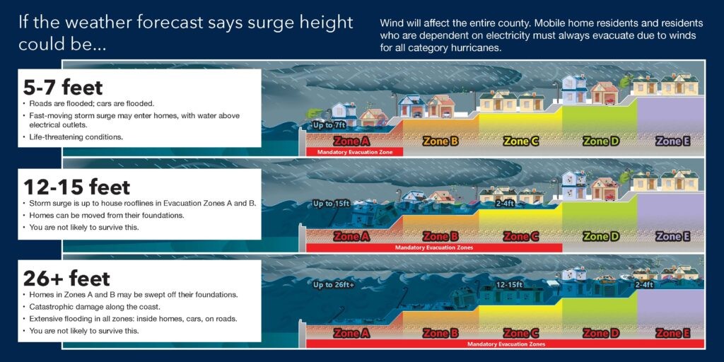
5. What Are the Most Vulnerable Areas for Inland Storm Surge?
Certain geographical features and land characteristics make some areas more susceptible to inland storm surge than others. Identifying these vulnerable zones is crucial for targeted preparedness and mitigation efforts.
-
Low-Lying Coastal Plains: These areas, characterized by gentle slopes and minimal elevation above sea level, offer little resistance to advancing storm surges. The surge can spread over vast distances, inundating homes, businesses, and infrastructure. Examples include the coastal regions of Florida, Louisiana, and North Carolina.
-
Riverine and Estuarine Areas: Rivers and estuaries act as conduits, channeling storm surge far inland. The surge can propagate upstream, flooding communities that are located well beyond the immediate coastline. The extent of inundation depends on the size and depth of the waterway, as well as the surrounding topography.
-
Bay and Sound Shorelines: Bays and sounds can amplify storm surge due to their enclosed nature and shallow waters. The surge can become trapped within these bodies of water, leading to higher water levels and more extensive flooding along the shorelines. Examples include Galveston Bay in Texas and Pamlico Sound in North Carolina.
-
Areas with Poor Drainage: Areas with inadequate drainage systems are particularly vulnerable to prolonged flooding from storm surge and rainfall. The surge can overwhelm drainage canals and pumps, leading to standing water and property damage.
-
Developed Coastal Areas: Densely populated coastal areas often have a higher concentration of infrastructure and assets at risk from storm surge. The economic and social impacts of a major storm surge event can be particularly severe in these areas.
-
Mobile Home Communities: Mobile homes are particularly vulnerable to wind and water damage during hurricanes. Residents of mobile home communities are often advised to evacuate regardless of their location within the evacuation zone.
Understanding the specific vulnerabilities of different areas is essential for developing effective risk management strategies. TRAVELS.EDU.VN recommends consulting local flood maps and emergency management plans to assess your personal risk and take appropriate preparedness measures.
6. What Kind of Damage Can Storm Surge Cause Inland?
The destructive power of storm surge extends far beyond the immediate coastline, causing a wide range of damage to inland areas. Understanding the potential impacts is crucial for effective preparedness and mitigation.
-
Flooding: The most obvious and widespread impact of storm surge is flooding. Inland areas can be inundated with several feet of water, causing damage to homes, businesses, and infrastructure. The depth and duration of flooding depend on the storm’s intensity, the local topography, and the presence of waterways.
-
Structural Damage: Storm surge can exert tremendous forces on buildings and infrastructure, leading to structural damage. Buildings can be undermined by erosion, and the force of the water can cause walls to collapse and roofs to be torn off. Bridges and roads can be washed away, disrupting transportation and isolating communities.
-
Erosion: Storm surge can cause significant erosion of coastlines and inland areas. The force of the water can scour away sand dunes, beaches, and soil, leading to land loss and damage to property. Erosion can also undermine coastal defenses, such as seawalls and levees, increasing the risk of future flooding.
-
Contamination: Storm surge can contaminate inland areas with saltwater, sewage, and hazardous materials. Saltwater intrusion can damage crops and contaminate freshwater supplies. Sewage spills can pose a public health risk. Hazardous materials, such as chemicals and petroleum products, can be released from storage tanks and industrial facilities, contaminating soil and water.
-
Debris: Storm surge can carry large amounts of debris inland, including trees, vehicles, and building materials. This debris can damage property, block roadways, and pose a hazard to navigation.
-
Economic Disruption: The damage caused by storm surge can lead to significant economic disruption. Businesses can be forced to close, jobs can be lost, and tourism can decline. The cost of recovery and rebuilding can be substantial.
The specific types and extent of damage caused by storm surge vary depending on the characteristics of the storm and the vulnerability of the affected area. TRAVELS.EDU.VN emphasizes the importance of flood insurance to help cover the costs of recovery from storm surge damage.
7. How Can Coastal Communities Prepare for Inland Storm Surge?
Effective preparation is crucial for minimizing the impacts of inland storm surge and protecting lives and property. Coastal communities can take a variety of measures to enhance their resilience to these events.
-
Develop Evacuation Plans: Evacuation plans should be based on the best available storm surge forecasts and should clearly identify evacuation routes and shelters. Communities should conduct regular drills to ensure that residents are familiar with the evacuation procedures.
-
Strengthen Building Codes: Building codes should be designed to withstand the forces of storm surge and wind. New buildings should be elevated above the base flood elevation, and existing buildings should be retrofitted to improve their resistance to flooding.
-
Invest in Flood Control Infrastructure: Flood control infrastructure, such as levees, seawalls, and drainage systems, can help to reduce the risk of storm surge inundation. These structures should be properly maintained and upgraded as needed to ensure their effectiveness.
-
Protect Natural Defenses: Natural defenses, such as barrier islands, sand dunes, and wetlands, can provide a buffer against storm surge. These areas should be protected and restored to enhance their ability to absorb wave energy and reduce the surge height.
-
Improve Communication and Education: Effective communication and education are essential for raising awareness of the risks of storm surge and promoting preparedness. Communities should provide residents with information on evacuation routes, shelter locations, and protective measures.
-
Establish Early Warning Systems: Early warning systems can provide timely alerts to residents about the approach of a hurricane and the potential for storm surge. These systems should be based on reliable weather forecasts and should be designed to reach as many people as possible.
-
Promote Community Resilience: Building community resilience involves empowering residents to take action to protect themselves and their property. This can include providing training on how to prepare for a hurricane, how to protect homes from flooding, and how to recover after a storm.
By implementing these measures, coastal communities can significantly reduce their vulnerability to inland storm surge and build a more resilient future. TRAVELS.EDU.VN encourages proactive planning and community involvement in preparedness efforts.
8. What Role Do Natural Barriers Play in Reducing Inland Storm Surge?
Natural barriers, such as barrier islands, sand dunes, and wetlands, play a vital role in reducing the impacts of inland storm surge by absorbing wave energy and reducing surge heights. Protecting and restoring these natural defenses is a key component of coastal resilience.
-
Barrier Islands: Barrier islands are long, narrow islands that run parallel to the mainland coast. They act as a first line of defense against storm surge, absorbing wave energy and reducing the surge height reaching the mainland. Barrier islands also provide habitat for a variety of plant and animal species.
-
Sand Dunes: Sand dunes are hills of sand that are formed by wind and wave action. They provide a natural barrier against storm surge, protecting coastal areas from flooding and erosion. Sand dunes also provide habitat for a variety of plant and animal species.
-
Wetlands: Wetlands are areas that are saturated with water, such as marshes, swamps, and bogs. They act as natural sponges, absorbing floodwaters and reducing the risk of flooding in inland areas. Wetlands also filter pollutants from water and provide habitat for a variety of plant and animal species.
-
Mangrove Forests: Mangrove forests are coastal ecosystems found in tropical and subtropical regions. They provide a natural barrier against storm surge, protecting coastlines from erosion and flooding. Mangrove forests also provide habitat for a variety of fish, birds, and other wildlife.
The effectiveness of natural barriers in reducing storm surge depends on their size, shape, and condition. Healthy and intact natural barriers provide the greatest level of protection. However, these natural defenses can be damaged or destroyed by human activities, such as coastal development, dredging, and pollution.
Protecting and restoring natural barriers is a cost-effective way to reduce the risks of storm surge and coastal erosion. This can be achieved through a variety of measures, such as:
- Restricting development in coastal areas
- Restoring damaged dunes and wetlands
- Planting vegetation to stabilize sand dunes
- Controlling invasive species
- Reducing pollution
By investing in natural defenses, coastal communities can enhance their resilience to storm surge and protect their economies and ecosystems. TRAVELS.EDU.VN supports sustainable coastal management practices that prioritize the preservation of natural resources.
9. How Can Individuals Protect Themselves from Inland Storm Surge?
While communities work to enhance their resilience to storm surge, individuals can also take steps to protect themselves and their families. Preparedness is key to minimizing the risks associated with these events.
-
Know Your Risk: Determine whether you live in an area that is vulnerable to storm surge. Consult local flood maps and emergency management plans to assess your risk.
-
Develop a Family Emergency Plan: Create a plan that outlines what you will do in the event of a hurricane or other coastal storm. This plan should include evacuation routes, shelter locations, and communication strategies.
-
Assemble a Disaster Supply Kit: Gather essential supplies, such as food, water, medicine, and first-aid supplies. Store these items in a waterproof container and keep them readily accessible.
-
Stay Informed: Monitor weather forecasts and heed warnings from local authorities. Pay attention to evacuation orders and be prepared to evacuate if necessary.
-
Protect Your Property: Take steps to protect your home from flooding. This can include elevating appliances, sealing walls, and installing flood barriers.
-
Purchase Flood Insurance: Flood insurance can help to cover the costs of repairing or replacing your home and belongings if they are damaged by flooding.
-
Evacuate When Ordered: If you are ordered to evacuate, do so promptly. Do not wait until the last minute to leave, as traffic congestion and hazardous conditions may make evacuation more difficult.
-
Never Drive Through Floodwaters: Driving through floodwaters can be extremely dangerous. The water may be deeper than it appears, and the current can be strong enough to sweep your vehicle away.
-
Stay Away from Downed Power Lines: Downed power lines can pose a serious electrocution hazard. Stay away from downed power lines and report them to the authorities.
By taking these steps, individuals can significantly reduce their risk of injury or death during a storm surge event. TRAVELS.EDU.VN encourages proactive planning and preparedness to ensure the safety of yourself and your loved ones.
10. What New Technologies Are Being Used to Study and Predict Storm Surge?
Advancements in technology are revolutionizing the way we study and predict storm surge, leading to more accurate forecasts and improved preparedness.
-
High-Resolution Modeling: Increased computing power has enabled the development of high-resolution storm surge models that can capture the complex interactions between the atmosphere, ocean, and land with greater detail. These models can simulate the flow of water around buildings and other obstacles, providing more accurate predictions of inundation at the local level.
-
Remote Sensing: Satellites, aircraft, and drones equipped with remote sensing instruments can collect data on sea surface height, wind speed, and wave conditions over large areas. This data can be used to improve the accuracy of storm surge models and to monitor the impacts of storms in real time.
-
Advanced Sensors: New types of sensors, such as underwater pressure sensors and high-frequency radar, can provide real-time measurements of water levels and wave conditions in coastal areas. This data can be used to validate storm surge models and to provide early warning of flooding.
-
Artificial Intelligence (AI): AI techniques, such as machine learning, are being used to develop new storm surge forecasting models that can learn from historical data and improve their accuracy over time. AI can also be used to analyze large datasets and identify patterns that may not be apparent to human analysts.
-
Citizen Science: Citizen science initiatives involve engaging the public in data collection and analysis. Volunteers can use mobile apps to report on water levels, wave conditions, and damage from storm surge. This data can be used to supplement data from traditional sources and to improve the accuracy of storm surge models.
These new technologies are helping to improve our understanding of storm surge and to provide more accurate forecasts. As technology continues to advance, we can expect even more improvements in our ability to predict and prepare for these devastating events. TRAVELS.EDU.VN is committed to staying at the forefront of these technological advancements and providing our users with the most up-to-date information on storm surge risks and preparedness measures.
Planning a trip to Napa Valley? Remember, TRAVELS.EDU.VN is your expert guide, providing seamless and unforgettable travel experiences.
Call to Action
Ready to explore Napa Valley without the stress of planning? Contact TRAVELS.EDU.VN today for personalized tour packages that cater to your unique preferences and budget. Let our experienced travel specialists handle all the details, ensuring a smooth and memorable vacation. Call us at +1 (707) 257-5400 or visit our website at travels.edu.vn. You can also visit us at 123 Main St, Napa, CA 94559, United States. Don’t wait, your Napa Valley adventure awaits]
FAQ: Storm Surge and Inland Travel
- How does storm surge differ from normal tides? Storm surge is an abnormal rise in sea level caused primarily by a storm’s winds pushing water onshore, whereas tides are the regular rise and fall of sea level due to the gravitational pull of the moon and sun.
- Can storm surge travel up rivers and streams? Yes, storm surge can travel significant distances inland by moving up rivers, streams, and other waterways, causing flooding in areas not directly on the coast.
- What is the most important factor determining how far inland storm surge will reach? The intensity of the storm, including wind speed and atmospheric pressure, is the primary factor influencing how far inland storm surge will travel.
- Are there any geographical features that can stop storm surge from traveling inland? Yes, natural features like bluffs, cliffs, and dense forests, as well as man-made structures such as levees and floodwalls, can impede the inland progress of storm surge.
- How can I find out if my home is in an area at risk of inland storm surge? Consult local government websites and emergency management agencies for storm surge inundation maps and risk assessments specific to your area.
- What should I do if I live in an area at risk of inland storm surge? Develop an evacuation plan, assemble a disaster supply kit, stay informed about weather alerts, and consider purchasing flood insurance.
- Is it safe to stay in a multi-story building during a storm surge? Staying in a multi-story building may be safer than being in a single-story home, but it’s essential to evacuate if local authorities advise, as even tall buildings can be at risk from severe flooding.
- How fast can storm surge waters rise? Storm surge can rise very quickly, sometimes several feet in just a few minutes, making it incredibly dangerous and necessitating prompt evacuation.
- Does the speed of a hurricane affect how far inland storm surge travels? Yes, the forward speed of a hurricane can influence the extent and severity of inland storm surge, as slower-moving storms can prolong the surge duration and increase inundation.
- Can climate change affect storm surge and how far it travels inland? Climate change contributes to rising sea levels, which can increase the base level for storm surges, allowing them to travel farther inland and cause more extensive flooding.